
Guide to Floating the Rio Grande
Floating the Rio: From Creede to Hannah Lane
Written by A.D. Dalton
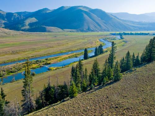
No river is more enjoyable to float and fly fish in summertime than the Rio Grande in Southern Colorado. The river begins in the alpine mountains above Creede, Colorado, and flows through South Fork, and on to the flattening valley floor at Del Norte. Within this stretch lies one of the most underdeveloped, pristine rivers in all of the Southwest. Both rainbows and browns abound, with many tributaries running into the Rio along the way. The South Fork/Creede area is the perfect destination for a first-time float trip on the Rio Grande. With the many guest ranches, bed and breakfasts and a couple hotels there is lodging to suit any budget. Much of the area is designated National Forest or Wilderness land, so camping areas are everywhere.
Our expert, A.D. Dalton takes you down the Rio in a series of float trips down the Rio.
Float Trip #1: Creede to Wagon Wheel Gap
 Directions to put-in: drive out of town heading west on Hwy 149 towards Lake City. After one mile there is a ninety-degree turn in the road, take the left road (Airport) a second mile toward the river passing the Mineral County Airport on your right and the Mountain Views RV Resort on your left. Public access boat ramp, latrines and parking on west side of road.
Directions to take-out: drive seven miles out of Creede heading east on Hwy 149 toward South Fork. After crossing the river a second time look for large parking lot and public river access across from cliffs on south side of the highway.
This float is a local favorite at the beginning of summer. Deep Creek runs into the Rio Grande across from the put-in. The first section of river has another public access point a mile down on the north side. Then you float past an old Division of Wildlife fish hatchery and the river quickly turns to private property, Wason Ranch.
There are grassy banks and cow pasture for miles. I’ve seen streamers ripped through the drops at the beginning before the guest ranch itself and grasshoppers with a dropper work great along the deep grassy banks down below. When the river is below 600 cfs this float takes around three hours (give or take how good you are at back-rowing). Most folks quit floating this section when it gets below 350. Between 400 and 500 is optimal. The second half of this float is through La Garita guest ranch, again all private. Bellows Creek comes into the river and throwing drys up under the willows in the dapple is the best way to nab a fish through here.
View in Fishing Directory
Float Trip #2: Wagon Wheel Gap to Palisade Campground
 Directions to put-in: drive thirteen miles out of South Fork heading west on Hwy 149 toward Creede. After passing Cottonwood Cove and 4UR Ranch, look for a large parking lot and public river access across from the steep cliffs on south side of the highway.
Directions to take-out: drive five miles past Wagon Wheel Gap to Palisade Campground located on the south side of Hwy 149 east toward South Fork. That would be twelve miles from the town of Creede heading east, and 8 miles from South Fork heading west.
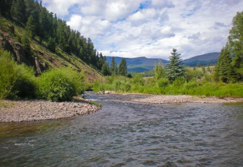
This trip is my personal favorite. The float starts out at Wagon Wheel Gap with towering cliffs rising 11,000 feet into the air. So named because Ute Indians would lie in wait for passing wagon trains to raid and then hang the wagon wheels from the cliffs in warning to other pale faces (a story my dad told me growing up). The train bridge you can see down river from the put-in is a tricky booger to navigate and I would suggest walking down and checking to see which passages are open through the bridge before you run it. Personally, I always stay river-middle because those are the bigger gaps. Also, the further left you go in the river the stronger the current, and the bridge sits at a bad angle in the current. Many folks portage around this bridge and, although it is not undoable, it is called "death bridge" by the locals for a reason…
The river again turns private as you travel through 4UR Guest Ranch and Cottonwood Cove. Goose Creek, which runs through 4UR, spills into the Rio Grande between the two ranches. The next section of river is the rock garden, a bony technical stretch to fish because of rapids and the rower stressing on how to ping pong down through it. (hint: stay river right!) I always fish the rock garden, and have had success with bigger drys. It has good presentation in a deep pool off the rapids and the fish know they have to react quickly or the snack is gone -- gotta love that fast moving water! Next you float past Blue Creek Lodge. Look for stairs up the bank to the highway and lodge, river left, after the rock garden and stop to have lunch. Its mostly public water from here on to Palisade Campground and Blue Creek dumps into the river right at the lodge. This stretch offers a much more wind- and sun-protected float versus up above and is more kid- and dog-friendly because you can stop along the banks if you need to. We fished this stretch last year around my birthday (June 16th) and the stonefly hatch was amazing! This is a two or three hour float and can be combined with the “Airport Road to Wagon Wheel Gap” float to make an all-day trip. As you will already know from running your shuttle, Palisade Campground sits on the north side of the river and has a short, steep boat ramp and parking lot.
View in Fishing Directory
Float Trip #3: Palisade Campground to Coller State Wildlife Area
 Directions to put-in: Palisade Campground is located on the south side of Hwy 149 twelve miles from the town of Creede heading east, and 8 miles from South Fork heading west.
Directions to take-out: four miles further east on Hwy 149 from Palisade Campground will find you at Coller State Wildlife Area. A right hand turn off the road you will see a green metal bridge and a parking lot. Hang left before the bridge and there is a small driveway down through the cottonwoods to the river.
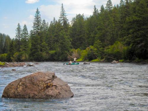
Palisade Campground to Coller is a shorter float with lots of potential (especially in the evening, it seems) to catch a fish in the high summer. We sometimes do this float in the long afternoon when work lets out and push getting off ‘til right at dusk. Towering pine trees dominate this stretch and the river widens considerably. A nice stop to stretch your legs and do some wade fishing is at the silver train bridge two miles down from Palisade. There are two nice sandbars on either side of the river before the bridge and you can hike around the area – it’s public. Next comes a few sets of rapids, and a concrete bridge known as Upper Coller. Some people do take-out here, known as the Telephone Pole Take-Out. It is narrow, steep and there is a large piece of metal in the river that could cause you problems in low water. I do feel the need to mention it, however, so folks know its there. It's a shame to take-out early here though, because around the bend from concrete bridge, the river has a very deep bank and I've seen many a fish caught in this stretch deep nymphing. This float can be combined with the “Wagon Wheel Gap to Palisade Campground” float for a long day-trip and stays floatable long after the “Airport Road to Wagon Wheel Gap” float has become too low. The take-out is an easy one with a long shallow rocky beach on the north side of the river right after you cross under the green metal bridge at Coller. The take-out at Coller is less than a mile from the Mineral County line.
View in Fishing Directory
Float #4: Lower Coller to Lower Alpine Take-Out
 Directions to put-in: Travel six miles west of the town of South Fork toward Creede. Turn at the Lower Coller State Wildlife Area sign on the south side of Hwy 149.
Directions to take-out: Travel three miles east of South Fork on Hwy 160 toward Del Norte. Turn left on County Road 19 across from Ute Bluff Lodge.
A good start to floating the river through South Fork is just past the western boundary fence at Masonic Park: a put-in for boats called Lower Coller. This is also a state designated Wildlife Area, so it’s likely you will catch a glimpse of a trophy elk or deer as they sip from the mighty Rio.
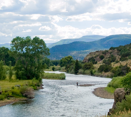
This adventure takes you through all the good stuff! After putting in at the public access of Lower Coller you will immediately find yourself floating onto private land belonging to the Mason's – view their “Masonic lodges” all along the Rio for about a mile. Strangely enough this is the only spot on the Rio Grande where it is legal to keep a rainbow trout - you conspiracy buffs can do the research to figure out why! All I know is that you can keep four trout, rainbow or brown, in accordance with state regulations, from here to the Hwy 149 bridge. The river is wide through this stretch, and the fishing is good right after run-off for stripping streamers. This is also one of the last floatable sections when the water gets low toward the end of season in July. The floats meanders through quaint neighborhoods of fishing cabins a few times but mostly enjoys quiet solitude with cottonwoods, aspens, spruce and pine trees dominating the mountain side. The Rio Grande Scenic Railroad runs along the river and the kids sure enjoy waving to the folks on board and hearing the train give a whistle. Further downstream you will float through Elk Creek Ranch (also private), before reaching town. You can recognize it for the big grassy hay meadows that roll towards the hillside to the south of the river.
The hamlet of South Fork six miles down from the put-in is a oasis on the east side of the Continental Divide. Should you need a latte from the Feelin Good Cafe or a beer at the Shaft Bar this town will accommodate! As you float under the Hwy 149 bridge, you are officially in Gold Medal Waters. (See current fishing regulations for Gold Medal Waters, typically two browns over 16 inches and all rainbows returned to the river). Floating through downtown takes you past the beautiful Rio Grande Club and Golf Course, with some of Rio Grande county's most luxurious stay-and-play ammonites. Its in these waters that the big trout hang out – enjoying deep rock pools and slow moving water. I know guys that get off work and float just from Hwy 149 bridge to the Lower Alpine take-out in the evening to cast a fly at these hogs. Big drys or drifting with nymphs -- either way its great fishing every time. The float ends at Franke Excavation/County Road 19 with a small takeout located on the northeast side of the bridge.
I would also like to add that boats have always been able to put-in/take-out at the Hwy 149 bridge access, but lately someone has put up signs everywhere for no trespassing, no parking ect. And the nearest parking is a long ways away. The access is still available, but because of the parking situation you can basically only get dropped of there.
Always respect private property and realize that many land-owners may be fickle. Many stories have been told over a post float beer about how you don’t have to match the hatch to get a rise out of a landowner near these put-ins and take-outs.
View in Fishing Directory
Float #5: Lower Alpine to Hanna Lane Bridge
Directions to the put-in: Travel 3 miles east on Hwy 160 to the left hand turn for County Road 19. Put-in under the bridge at the river on the northeast side of the road.
Directions to the takeout: Get back out on Hwy 160 from County Road 19 and travel 8 miles east toward Del Norte. The Hanna Lane/County Road 15 turn is on the north side of Hwy160. Proceed one mile to Hanna Lane bridge and look for driveway/river access on the southeast side of the bridge.
The Hanna Lane float is not for the faint of heart. While one of the best sections of the Gold Medal Waters, it is also one of the longest. The river is wider and slower and begins to snake through this section adding miles with every turn. The fish are the largest and most finicky you will encounter in all of the Rio Grande River. When the wind blows you will have to row yourself downriver! That being said, can you tell I’m trying to scare you off one of my favorite sections of river? I love this float in early summer before the mosquitoes are a menace. Any boat from a personal pontoon to a sixteen foot maravia raft can go down this stretch. With huge cottonwoods, hay pastures and foothills of sage in the distance, its a sight to behold, this piece of the Rio. River Island Ranch and their neighbor Silo Ranch run cattle and horses on the meadows and elk, deer and the occasional antelope can be seen.
The biggest brown I've ever seen caught on the Rio Grande was in this stretch! However once again, there are a few things to consider: 1. It is all private lands. There is no in-between spots to take-out and rest; and 2. The bugs can be unbearable mid summer -- I mean, we are all bug-loving fisherman, but once “Off” spray seems like attractant vs. repellant, I'm done!
The best part of this float is the couple-mile-stretch just before the take-out. Enjoy public access wade fishing along the bank to the west of the take-out on the north side of the river. If you still haven't had enough or you just want to wade fish the next morning before heading out of town, try this area on Hanna Lane. I waded it two weeks ago in April and saw a giant blue heron wade fishing against the sunset and almost got struck by lighting. Lord, I love the big river.